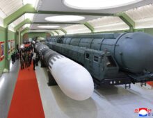
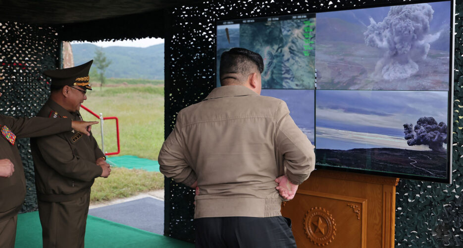
Kim Jong Un watches purported footage of a missile striking a target in the Tonggye Wildlife Sanctuary | Image: KCNA (Sept. 19, 2024)
The inland target range that North Korea used to test a new missile last week is located in a protected wildlife reserve in the country’s remote northeast, an NK Pro investigation has found, offering clues about the DPRK’s claims of improved precision capabilities.
The North Korean military appeared to fire the Hwasong-11C-4.5 at a target inside the Tonggye Wildlife Sanctuary (동계동물보호구) that straddles the border of Paekam County in Ryanggang Province and Orang County in North Hamgyong Province, according to NK Pro analysis of satellite imagery and state media photos.
It is North Korea’s first confirmed inland target site for ballistic missiles. The DPRK military has mostly used islands off the northeast coast during tests in recent years, though these often did not demonstrate great precision.
The Korean Central News Agency (KCNA) claimed that leader Kim Jong Un oversaw a test of the Hwasong-11C-4.5 on Sept. 18, with the name referencing the short-range ballistic missile’s (SRBM) “4.5 ton super-large conventional warhead.”
KCNA stated an unspecified number of missiles accurately struck a target 320 km away, publishing images of at least two missiles.
It was the second known test of this system after the first in early July. The Hwasong-11C was previously tested in Oct. 2022 and with a 2.5-ton warhead in March 2021, and it is also designed to carry nuclear warheads.
The missiles appear to be manufactured at the February 11 Factory in Hamhung, and its transporter erector launcher vehicles (TELs) at the March 16 Factory in Phyongsong.
Kim Jong Un and top military officials stand on the Kaechon Airbase runway looking toward the reported Hwasong-11C-4.5 SRBM launch site, which appears to be behind a row of aircraft revetments to the northeast of the runway | Image: KCNA (Sept. 19, 2024)
Kim Jong Un points to the missile target site at Tonggye Wildlife Sanctuary | Image: KCNA (Sept. 19, 2024)
Kim Jong Un points to the missile target site at Tonggye Wildlife Sanctuary | Image: KCNA (Sept. 19, 2024)
A missile glows from heat during the terminal stage as it appears to strike the circular target site at the Tonggye Wildlife Sanctuary | Image: KCNA (Sept. 19, 2024)
A missile appears to strike the circular target site at the Tonggye Wildlife Sanctuary | Image: KCNA (Sept. 19, 2024)
A missile appears to strike the circular target site at the Tonggye Wildlife Sanctuary | Image: KCNA (Sept. 19, 2024)
A missile glows from heat during the terminal stage as it appears to strike the circular target site at the Tonggye Wildlife Sanctuary | Image: KCNA (Sept. 19, 2024)
A missile appears to strike the circular target site at the Tonggye Wildlife Sanctuary | Image: KCNA (Sept. 19, 2024)
A missile appears to strike the circular target site at the Tonggye Wildlife Sanctuary | Image: KCNA (Sept. 19, 2024)
A missile glows from heat during the terminal stage as it appears to strike an X-shaped target site, possibly also at the Tonggye Wildlife Sanctuary | Image: KCNA (Sept. 19, 2024)
A missile appears to strike an X-shaped target site, possibly also at the Tonggye Wildlife Sanctuary | Image: KCNA (Sept. 19, 2024)
ASSESSING SEPT. 18 TEST ACCURACY
South Korea’s Joint Chiefs of Staff (JCS) identified the Sept. 18 SRBM launch location as Kaechon County. NK Pro confirmed it as Kaechon Airbase in South Phyongan Province after comparing state media photos with Google Earth satellite imagery.
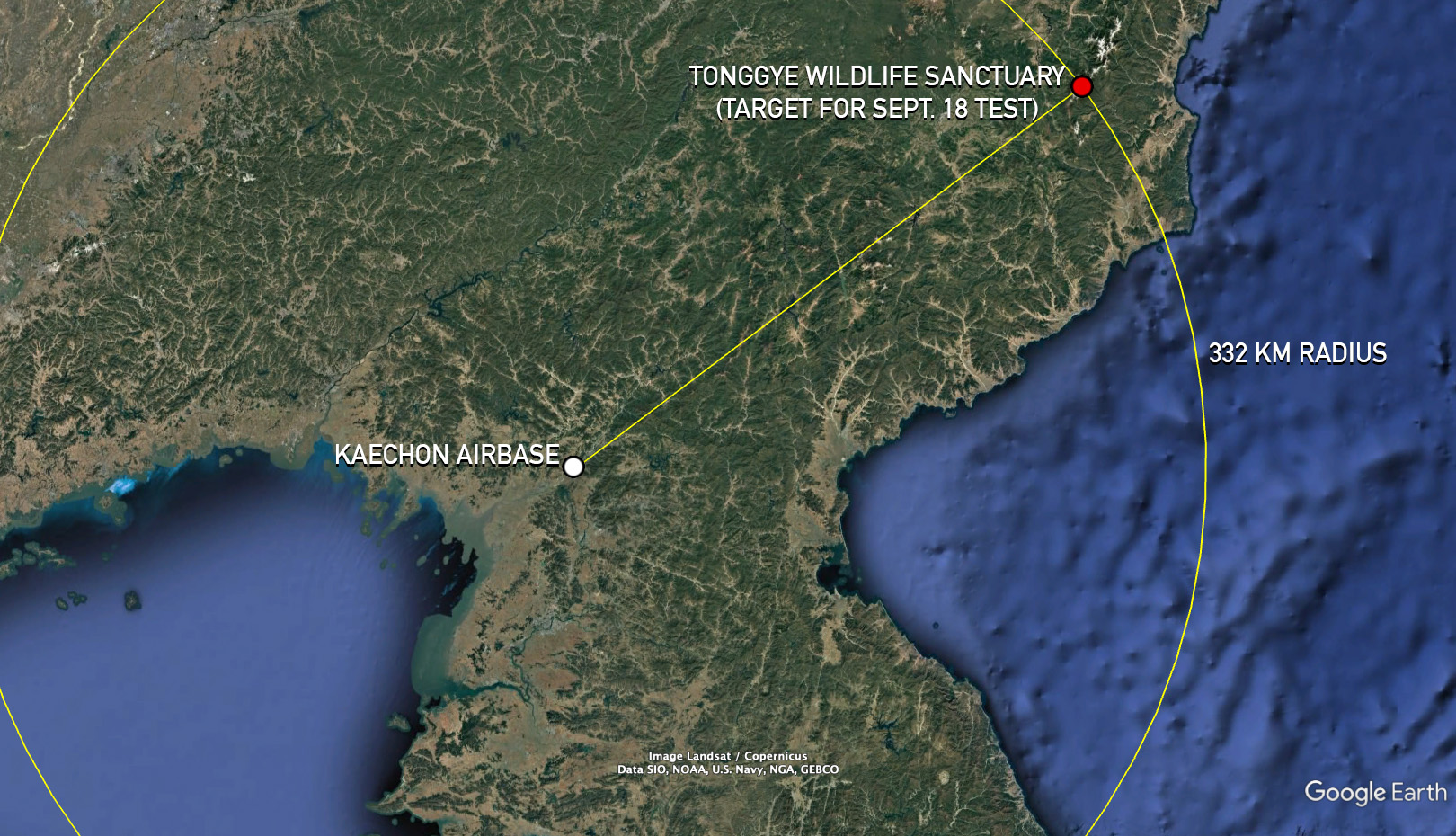
One photo published on Sept. 19 showed Kim looking at a blurred display of a map or satellite photo of the missile target location, including text that appears to read “Distance: 332.1 km,” more than the 320 km distance mentioned in the KCNA report.
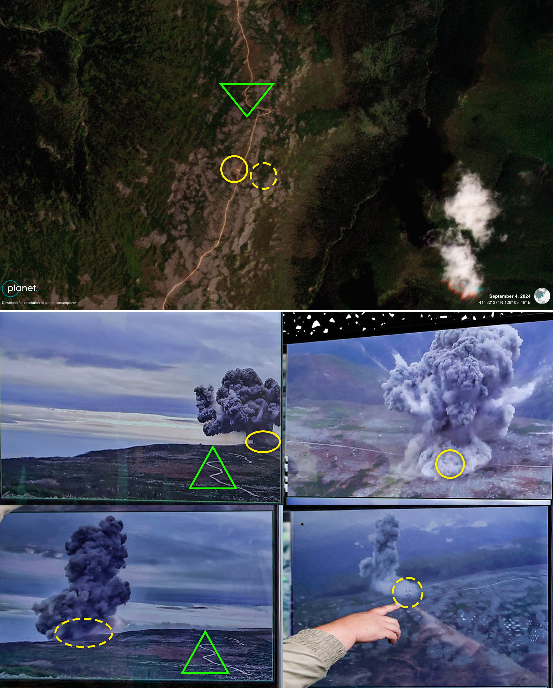
NK Pro matched the appearance of the overhead shot of the target location and multiple aerial and ground-level photos of the missile striking a circular target to a pre-prepared target area exactly 332 km from the missile launch spot at Kaechon Airbase.
The target is located along a newly built road on a plateau near Kwesam Peak (궤삼봉), 2,332 meters (1.45 miles) above sea level and right in the middle of the Tonggye Wildlife Sanctuary.
These color medium-resolution satellite images taken on Sept. 4 and 28, before and after the Sept. 18 missile test, show evidence of an explosion or missile strike at a prepared target area. Another site to the north also showed signs of soil displacement, but it doesn’t match any of the KCNA photos of the test target site. | Image: Planet Labs (Sept. 4, 2024), edited by NK Pro
These color medium-resolution satellite images taken on Sept. 4 and 28, before and after the Sept. 18 missile test, show evidence of an explosion or missile strike at a prepared target area. Another site to the north also showed signs of soil displacement, but it doesn’t match any of the KCNA photos of the test target site. | Image: Planet Labs (Sept. 23, 2024), edited by NK Pro
These modified soil-adjusted vegetation index (MSAVI2) medium-resolution satellite images taken on Sept. 4 and 28, before and after the Sept. 18 missile test, show evidence of an explosion or missile strike at a prepared target area. Another site to the north also showed signs of soil displacement, but it doesn’t match any of the KCNA photos of the test target site. | Image: Planet Labs (Sept. 4, 2024), edited by NK Pro
These modified soil-adjusted vegetation index (MSAVI2) medium-resolution satellite images taken on Sept. 4 and 28, before and after the Sept. 18 missile test, show evidence of an explosion or missile strike at a prepared target area. Another site to the north also showed signs of soil displacement, but it doesn’t match any of the KCNA photos of the test target site. | Image: Planet Labs (Sept. 23, 2024), edited by NK Pro
Overlaying KCNA aerial images of the circular target spot with high-resolution satellite imagery of the Tonggye Wildlife Sanctuary results in a perfect match of distinct landscape features | Images: KCNA (Sept. 19, 2024), Google Earth (July 9, 2019), edited by NK Pro
Overlaying KCNA aerial images of the circular target spot with high-resolution satellite imagery of the Tonggye Wildlife Sanctuary results in a perfect match of distinct landscape features | Images: KCNA (Sept. 19, 2024), Google Earth (July 9, 2019), edited by NK Pro
These two images demonstrate that Kim Jong Un was looking at a trajectory map and target location of the Tonggye Wildlife Sanctuary, with the white and red dot marking the circular target spot seen in satellite imagery | Image: KCNA (Sept. 19, 2024), Planet Labs (Sept. 23, 2024), edited by NK Pro
These two images demonstrate that Kim Jong Un was looking at a trajectory map and target location of the Tonggye Wildlife Sanctuary, with the white and red dot marking the circular target spot seen in satellite imagery | Image: KCNA (Sept. 19, 2024), edited by NK Pro
State media has reported multiple times in recent years on the sanctuary’s many “animals greatly worth protecting” such as musk deer, sable, mountain goats, large bears and over 100 bird species.
Planet Labs imagery shows evidence of an explosion at the sanctuary in the center of the target circle (coordinates: 41.54241° N, 129.05863° E), which appeared to have a diameter of about 15 to 20 meters, though it is difficult to confirm its precise size and condition prior to Sept. 18 as there are no recent commercially available high-resolution images of the site.
The target area was first set up between July 19 and Aug. 6, well ahead of the test.
The target is along an 8.5 km-long road on the plateau that was built starting between June 20 and 27 toward what appears to be a new military installation, such as a missile or anti-aircraft artillery launch site, on Kwesam Peak.
This set of four color images shows progress on building a new apparent military installation atop Kwesam Peak since late June, as well as possible evidence of missile strikes related to the July 1 Hwasong-11C-4.5 SRBM test | Image: Planet Labs (June 27, 2024), edited by NK Pro
This set of four color images shows progress on building a new apparent military installation atop Kwesam Peak since late June, as well as possible evidence of missile strikes related to the July 1 Hwasong-11C-4.5 SRBM test | Image: Planet Labs (July 10, 2024), edited by NK Pro
This set of four color images shows progress on building a new apparent military installation atop Kwesam Peak since late June, as well as possible evidence of missile strikes related to the July 1 Hwasong-11C-4.5 SRBM test | Image: Planet Labs (Sept. 4, 2024), edited by NK Pro
This set of four color images shows progress on building a new apparent military installation atop Kwesam Peak since late June, as well as possible evidence of missile strikes related to the July 1 Hwasong-11C-4.5 SRBM test | Image: Planet Labs (Sept. 23, 2024), edited by NK Pro
A DPRK map showing the outline of the Tonggye Wildlife Sanctuary | Image: DPRK Atlas
The evidence suggests North Korea’s Hwasong-11C SRBM has attained a level of precision at what Pyongyang refers to as the missile’s “medium range” of around 330 km.
However, given North Korea’s past tendency to lie about the success of missile tests and fake evidence, it is difficult to confirm with absolute certainty that the ground displacement at the target was a result of a missile strike and not a set charge. Such a scenario would entail missile impacts in other, possibly unintended locations, which should be visible in satellite imagery.
North Korea similarly attempted to demonstrate the precision accuracy of its improved 240mm MLRS in late August, but a comparison of satellite imagery of the prepared target site taken just before and after the claimed test do not conclusively show evidence of rocket strikes.
Seoul and Tokyo haven’t released details about where they detected missiles landing in the most recent Hwasong-11C-4.5 test.
If the test primarily served as an advertisement of the missile system to Russia, as some experts have argued, Kim Jong Un would likely provide additional data behind the scenes that would help prove the claims of the test’s accuracy. In this case, releasing some details and photos of the test publicly through state media would likely be intended to improve message credibility.
COUNTING MISSILES
South Korea’s JCS said North Korea fired “multiple” missiles on Sept. 18 and Japan’s defense ministry stated launches of an unspecified number of missiles took place at two different times that morning, 6:53 and 7:23 a.m. KST.
KCNA published eight ground-level or aerial photos of missiles striking targets. Six of them appear to be of one missile striking the circular target, with the other two are of a different missile striking an X-shaped target.
Two additional photos showed Kim Jong Un looking at TV screens on the Kaechon Airbase runway likely moments apart, showing various angles of an apparent live-feed of the circular target site.
This geolocation reference collage shows satellite imagery of the Tonggye Wildlife Sanctuary before and after the Sept. 18 missile test and one year ago when vegetation conditions were similar but the new road and installation weren’t yet built. KCNA photos at the bottom all appear to depict a single missile strike or explosion at the circular target area. Solid yellow circles correspond to the target spot, dotted-line circles show where the column of smoke appeared to drift eastward toward the other side of the road, and the green triangle denotes a part of the winding road on the plateau. | Images: Planet Labs (Sept. 4, 2024), KCNA (Sept. 19, 2024), edited by NK Pro
This geolocation reference collage shows satellite imagery of the Tonggye Wildlife Sanctuary before and after the Sept. 18 missile test and one year ago when vegetation conditions were similar but the new road and installation weren’t yet built. KCNA photos at the bottom all appear to depict a single missile strike or explosion at the circular target area. Solid yellow circles correspond to the target spot, dotted-line circles show where the column of smoke appeared to drift eastward toward the other side of the road, and the green triangle denotes a part of the winding road on the plateau. | Images: Planet Labs (Sept. 23, 2024), KCNA (Sept. 19, 2024), edited by NK Pro
This geolocation reference collage shows satellite imagery of the Tonggye Wildlife Sanctuary before and after the Sept. 18 missile test and one year ago when vegetation conditions were similar but the new road and installation weren’t yet built. KCNA photos at the bottom all appear to depict a single missile strike or explosion at the circular target area. Solid yellow circles correspond to the target spot, dotted-line circles show where the column of smoke appeared to drift eastward toward the other side of the road, and the green triangle denotes a part of the winding road on the plateau. | Images: Planet Labs (Sept. 28, 2023), KCNA (Sept. 19, 2024), edited by NK Pro
This geolocation reference collage shows satellite imagery of the Tonggye Wildlife Sanctuary before and after the Sept. 18 missile test and one year ago when vegetation conditions were similar but the new road and installation weren’t yet built. KCNA photos at the bottom all appear to depict a single missile strike or explosion at the circular target area. Red rectangles correspond to matching ground features, and yellow circles denote the target spot. | Images: Planet Labs (Sept. 4, 2024), KCNA (Sept. 19, 2024), edited by NK Pro
This geolocation reference collage shows satellite imagery of the Tonggye Wildlife Sanctuary before and after the Sept. 18 missile test and one year ago when vegetation conditions were similar but the new road and installation weren’t yet built. KCNA photos at the bottom all appear to depict a single missile strike or explosion at the circular target area. Red rectangles correspond to matching ground features, and yellow circles denote the target spot. | Images: Planet Labs (Sept. 23, 2024), KCNA (Sept. 19, 2024), edited by NK Pro
This geolocation reference collage shows satellite imagery of the Tonggye Wildlife Sanctuary before and after the Sept. 18 missile test and one year ago when vegetation conditions were similar but the new road and installation weren’t yet built. KCNA photos at the bottom all appear to depict a single missile strike or explosion at the circular target area. Red rectangles correspond to matching ground features, and yellow circles denote the target spot. | Images: Planet Labs (Sept. 28, 2023), KCNA (Sept. 19, 2024), edited by NK Pro
There are no other spots in the area that show significant signs of ground displacement after the Sept. 18 missile test when compared to Sept. 4 images.
Evidence of digging or construction, or possibly even missile strikes, appeared in that time in round pits at the apparent military installation atop Kwesam Peak, but the geography of this spot does not match the two KCNA photos of the X-shaped target on a hillside.
This raises the question of where the X-shaped target is located, and whether the photos of this strike were taken on Sept. 18 or on July 1 when KCNA last claimed the Hwasong-11C-4.5 was tested.
The natural features around the X target appear similar to the environment in the other photos of the circular target in the Tonggye reserve.
JULY TEST
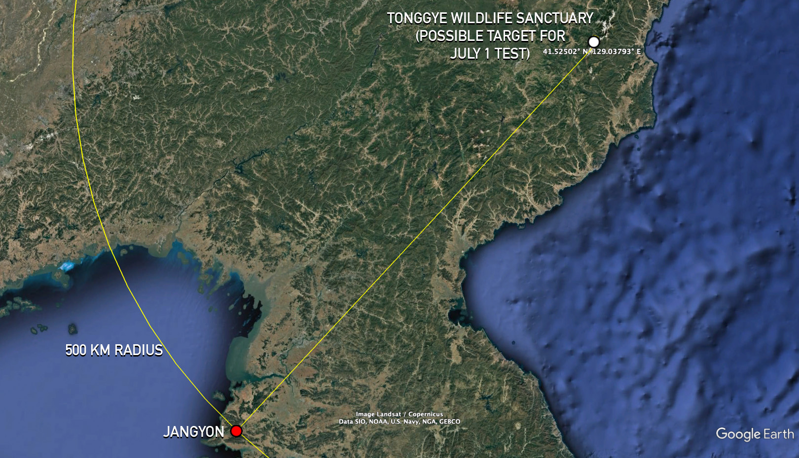
North Korean state media said at least two missiles were tested at different distances on July 1 — a “maximum range” of 500 km and “minimum range” of 90 km — while JCS determined two missiles were launched from Jangyon County in South Hwanghae Province.
The DPRK report also said the Missile Administration would test the Hwasong-11C-4.5 “at the medium range of 250 km [on a later date] in July” to “verify flight characteristics, hit accuracy and explosion power of super-large warhead,” but this test was delayed until last week and the target distance was increased to over 330 km.
JCS spokesperson Lee Seong-joon said at the time “it’s highly likely that calling [both launches] a success is a lie since it’s extremely rare for tests to involve an inland [target].” He also suggested the shorter-range launch was actually a failure that state media was trying to cover up.
KCNA didn’t release any photos, but Planet Labs imagery suggests the same area in the Tonggye Wildlife Sanctuary was used as a target for that test as well.
This set of four MSAVI2 images shows progress on building a new apparent military installation atop Kwesam Peak since late June, as well as possible evidence of missile strikes related to the July 1 Hwasong-11C-4.5 SRBM test | Image: Planet Labs (June 27, 2024), edited by NK Pro
This set of four MSAVI2 images shows progress on building a new apparent military installation atop Kwesam Peak since late June, as well as possible evidence of missile strikes related to the July 1 Hwasong-11C-4.5 SRBM test | Image: Planet Labs (July 10, 2024), edited by NK Pro
This set of four MSAVI2 images shows progress on building a new apparent military installation atop Kwesam Peak since late June, as well as possible evidence of missile strikes related to the July 1 Hwasong-11C-4.5 SRBM test | Image: Planet Labs (Sept. 4, 2024), edited by NK Pro
This set of four MSAVI2 images shows progress on building a new apparent military installation atop Kwesam Peak since late June, as well as possible evidence of missile strikes related to the July 1 Hwasong-11C-4.5 SRBM test | Image: Planet Labs (Sept. 23, 2024), edited by NK Pro
This map shows the distance and trajectory between the Kaechon Airbase launch spot of the Hwasong-11C-4.5 SRBM on Sept. 18 and the Tonggye Wildlife Sanctuary | Image: Google Earth, edited by NK Pro
This map shows that the Tonggye Wildlife Sanctuary is 500 km away from Jangyon County, where JCS said North Korea’s claimed Hwasong-11C-4.5 launch on July 1 took place | Image: Google Earth, edited by NK Pro
This set of three images shows KCNA photos published on Sept. 19 of a missile striking an X-shaped target, likely at the Tonggye Wildlife Sanctuary, as well as a patch of ground near the new military installation there which appears to have similar geographical features and which showed evidence of soil displacement, possibly from an explosion, around the July 1 Hwasong-11C-4.5 test | Image: KCNA (Sept. 19, 2024), edited by NK Pro
This set of three images shows KCNA photos published on Sept. 19 of a missile striking an X-shaped target, likely at the Tonggye Wildlife Sanctuary, as well as a patch of ground near the new military installation there which appears to have similar geographical features and which showed evidence of soil displacement, possibly from an explosion, around the July 1 Hwasong-11C-4.5 test | Image: KCNA (Sept. 19, 2024), edited by NK Pro
This set of three images shows KCNA photos published on Sept. 19 of a missile striking an X-shaped target, likely at the Tonggye Wildlife Sanctuary, as well as a patch of ground near the new military installation there which appears to have similar geographical features and which showed evidence of soil displacement, possibly from an explosion, around the July 1 Hwasong-11C-4.5 test | Image: Google Earth (July 9, 2019), edited by NK Pro
One hillside location which showed significant change before and after the July test appears similar to the ground photos published last week of the X-shaped target site (coordinates: 41.52503° N, 129.03789° E). It is also located 500 km from the claimed launch site of Jangyon County.
Overall, the timing of the construction of the new road and installation in the last week of June leading up to the July 1 test also suggests this was the target area utilized for that test, which both JCS and Japan described as being located inland.
It’s possible the area will be used during more missile tests in the future, while high-resolution imagery should help clarify the purpose of the possible launch installation nearby, where two structures each measuring over 10 by 10 meters appeared to be installed between Sept. 4 and 23.
Colin Zwirko is a Senior Analytic Correspondent for NK News based in Seoul. He joined the company in 2018 after receiving a master's degree in international security and foreign policy from South Korea's Yonsei University. Follow him on Bluesky / Twitter.











 SHARE
SHARE COPY LINK
 X
X MASTODON