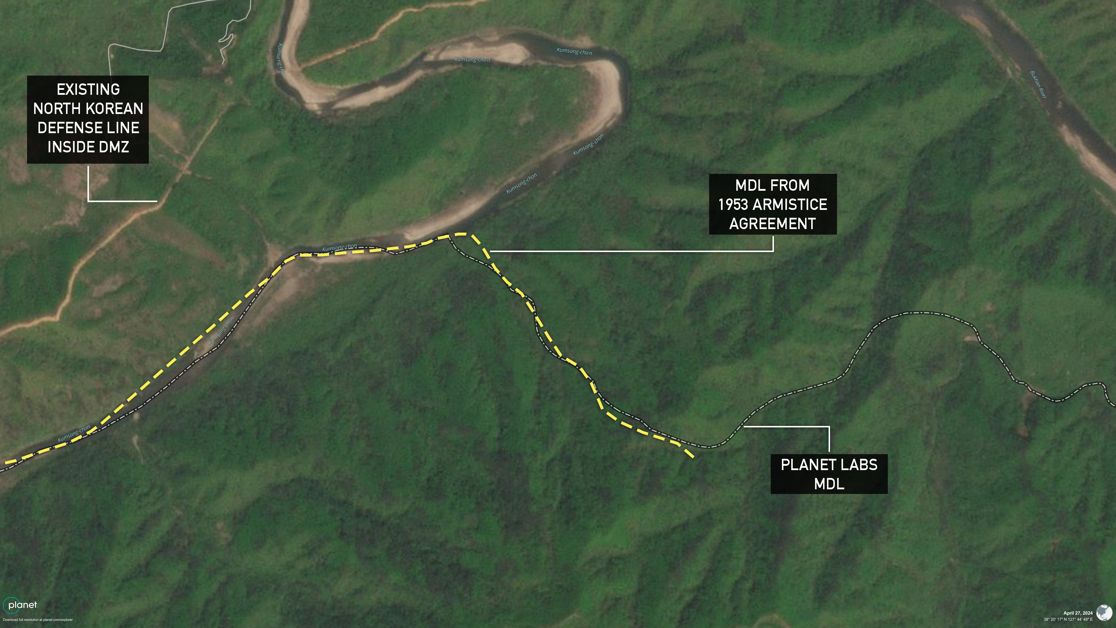
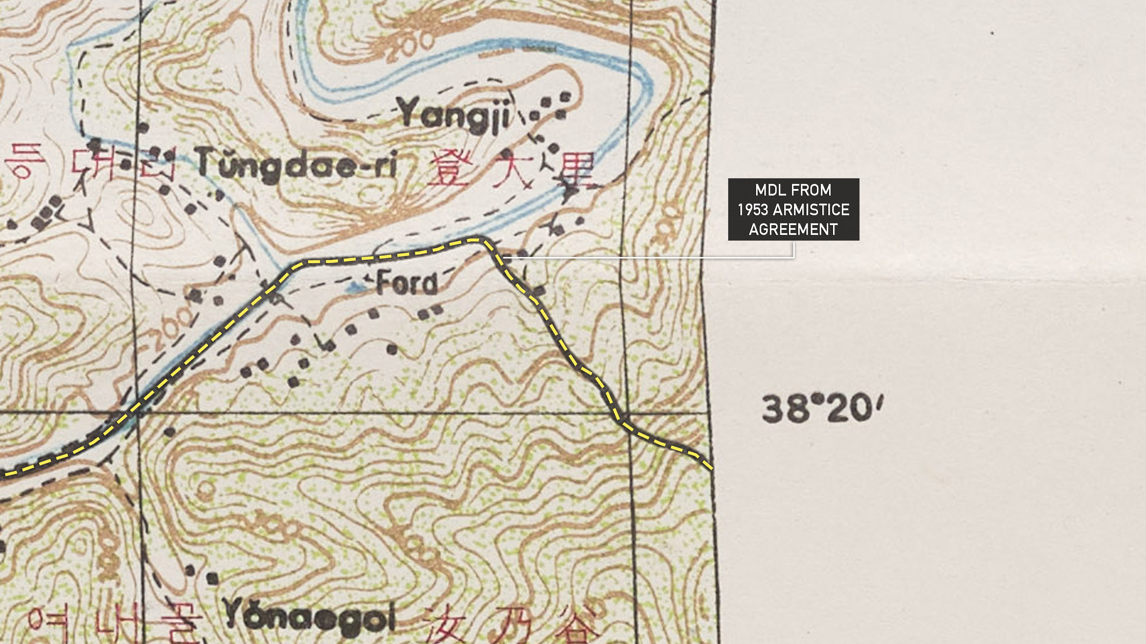
  Analysis New North Korean defense line crosses border with South, armistice maps confirmNK Pro analysis shows two new paths touch or cross Military Demarcation Line, the first such activity in decades 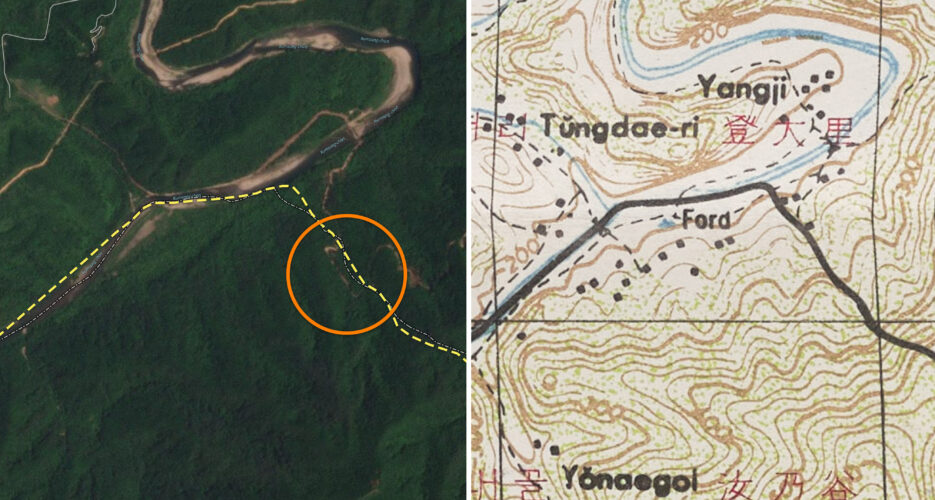 North Korea is building new forward defense lines that touch and even cross the Military Demarcation Line (MDL) dividing the two Koreas, according to NK Pro analysis of satellite imagery. Experts told NK Pro that the apparent DPRK activity across the MDL will likely require a South Korean response and could lead to “escalation” and “bloodshed.” NK News previously reported on North Korean construction at six different areas inside the demilitarized zone (DMZ) since early May, but satellite imagery and 1953 Armistice Agreement maps now reveal that the DPRK has cleared at least one path that extends into the South Korean side of the DMZ for the first time in decades. It comes as South Korean military authorities revealed details of continued large-scale construction activities by DPRK soldiers in the DMZ on Tuesday, including instances where soldiers were killed by exploding landmines. South Korea’s Ministry of National Defense has declined to respond to NK Pro inquiries about North Korea’s recent activities in the DMZ, only confirming two instances of DPRK soldiers encroaching on the border line in recent weeks. The purpose and scope of the North’s efforts in the DMZ are not yet clear, though it could relate to new anti-unification policies adopted this year and stated intentions to redraw the country’s borders. The Armistice Agreement ended active fighting in the Korean War, and attached maps agreed on at the time established the northern and southern boundary lines of the DMZ and the MDL at roughly midway between them. Neither side’s military is allowed to cross the MDL under the agreement, though it is only marked by aging signposts and not a fence. CROSSING THE LINE Armistice Agreement maps and NK Pro analysis of Planet Labs imagery show a new North Korean defense line was built south of the MDL between April 27 and May 1 (coordinates: 38.33794° N, 127.74513° E). This is located between Kimhwa County in the North and Cheorwon County in the South. The path appears to extend at least 130 feet (40 meters) up a hill into the other side of the MDL. It extends almost 1,000 feet (300 meters) before turning and crossing the MDL again back onto North Korea’s side of the DMZ. 
Chris Wagner, a former U.S. military officer tasked with monitoring the inter-Korean border, told NK Pro that while the crossing probably “does not serve a real tactical military purpose,” the path could be “a low-risk provocation attempt to force a disproportionate response from ROK to justify further escalation.” Suon Choi, an associate research fellow at the Korea Institute for Defense Analyses, said South Korea cannot afford to overlook actions by the North Korean military that cross the MDL. “In particular, constructing pathways beyond the MDL is not an accidental act but an intentional one,” the expert said, adding that such actions could lead to escalation. Both North and South Korea have built forward defense lines and fences inside the DMZ, going beyond their respective boundary lines and, in some cases, running close to the MDL. But the recent construction marks the first known attempt to construct a new defense line over the MDL in decades. Further east between Kumgang County in the North and Inje County in the South (coordinates: 38.38642° N, 128.22124° E), another new DPRK defense line appears to have been built in a valley right up to and possibly just crossing the MDL. The work occurred between March 22 and 23, Planet Labs imagery shows. 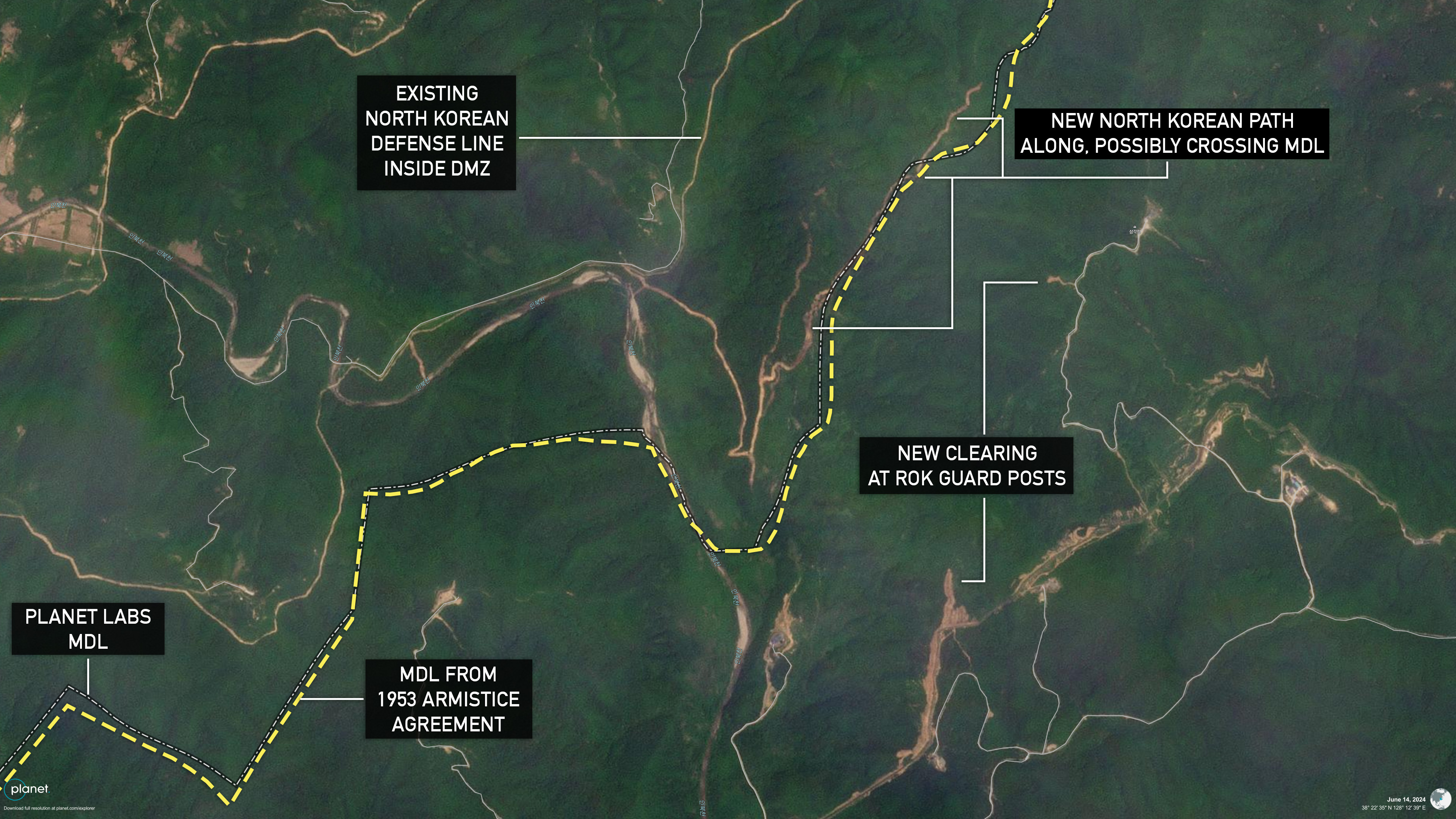
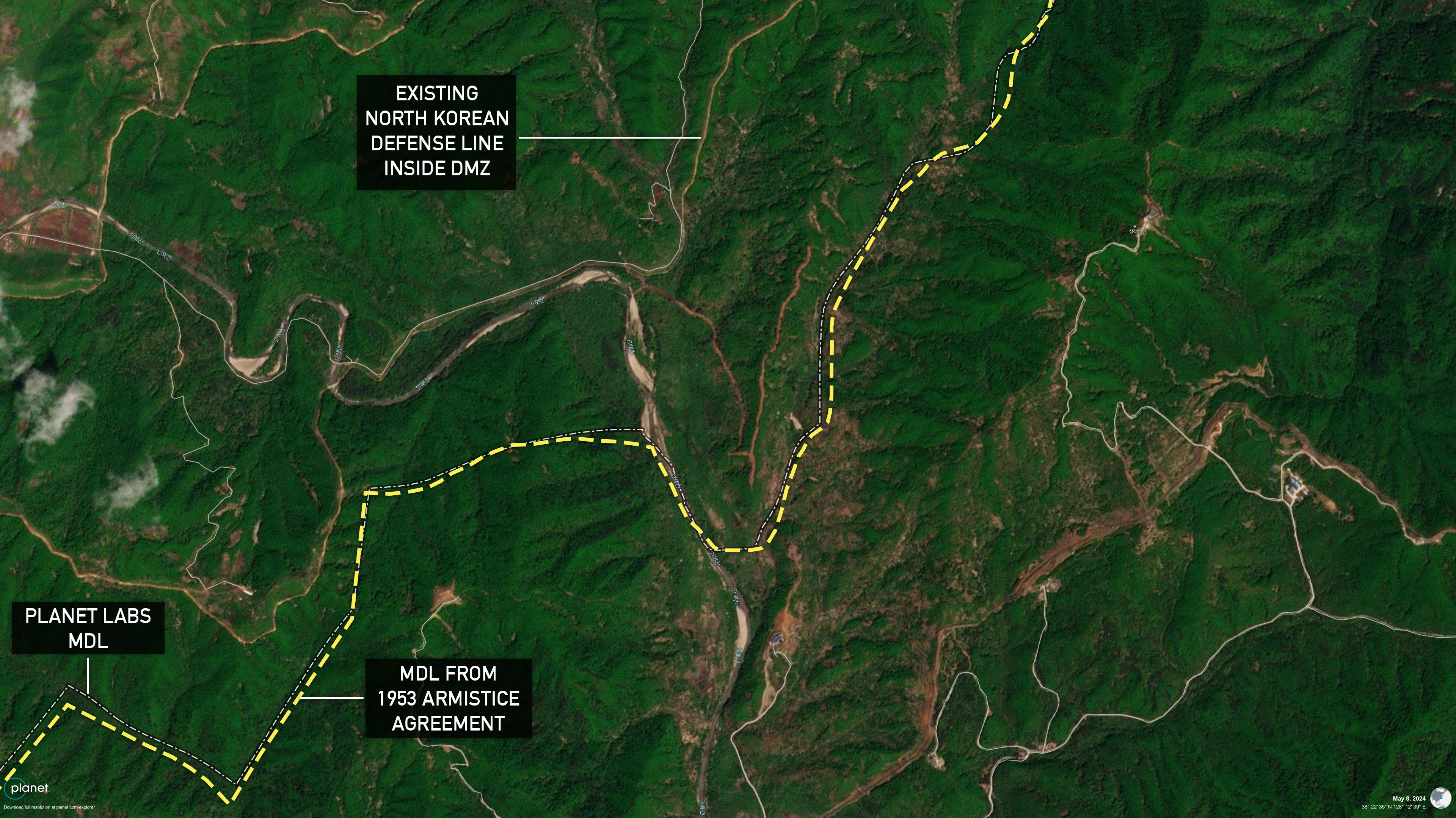
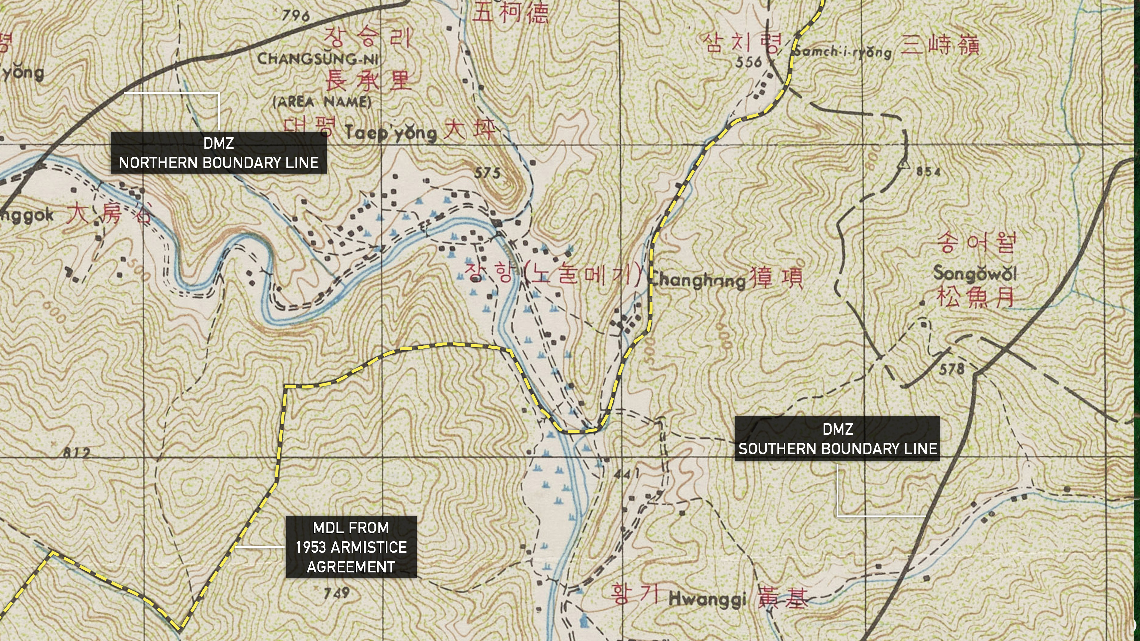
Imagery also shows new tree clearing by South Korea on its side in the weeks since. The work took place at two spots along a mountain ridge overlooking the new North Korean defense line near the MDL, suggesting the ROK military is closely watching the activity. Following the publication of this article, South Korea’s defense ministry told NK Pro that “there have been no incursions by North Korean forces across the MDL to construct tactical roads or similar structures.” “The lines depicted as the MDL in the article, which rely on historical maps and satellite images do not correspond to the actual location of the MDL,” a spokesperson said. “The precise military maps detailing the exact location of the MDL are classified for security reasons and therefore, cannot be provided.” But Steve Tharp, a retired U.S. Army lieutenant colonel who worked at the Joint Security Area for six years, contested the ministry’s claim that the location of the MDL is classified. “The MDL and its maps can’t be classified because they were agreed to between U.N. Command, the People’s Volunteer Army and the Korean People’s Army,” he said “The historical maps are the actual source for the MDL. They can’t be wrong.” Retired ROK Lt. Gen. Chun In-bum, who served as a battalion commander along the eastern part of the inter-Korean border, told NK Pro that MDL crossings by the North “whether deliberate or by accident … will invite action that could lead to bloodshed.” An NK Pro review of satellite imagery across the entire DMZ since April did not reveal similar large-scale efforts on South Korea’s side to build new defense lines and paths. Meanwhile, South Korean outlet MBN reported that a claimed instance of North Korean soldiers crossing the MDL on June 9 occurred just north of a South Korean guard post on Arrowhead Hill (화살머리고지). This is the same spot NK News reported was the site of a new North Korean path earlier this month, though the path only appears to run parallel to the MDL within around 300 feet (100 meters) without crossing it. The United Nations Command was reportedly in talks in 2014 to reinstall missing MDL signposts using GPS to accurately follow the line as dictated by the Armistice Agreement, but the project did not appear to go ahead. 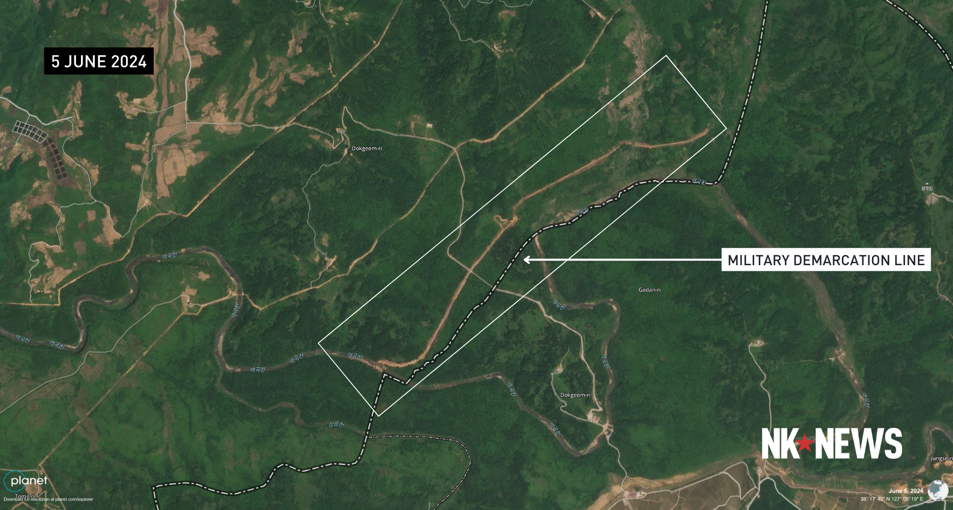 Updated on 20 June at 9 a.m. KST with a response from South Korea’s Ministry of National Defense and additional expert comment. Edited by Bryan Betts © Korea Risk Group. All rights reserved. |

October 14, 2026Oct 14, 2026

The ultimate resources for professionals working on North Korea
 SHARE
SHARE COPY LINK
 X
X MASTODON